Funky Geography
Funky Geography: Nerding Out About Maps
One of these days I’m going to make a phylogenic tree of nerdiness. Beyond the well-known nerd species (computer programmer, D&D, WoW) and the lesser-known nerds (Civil War reenactors, fantasy footballers) lie little pockets of nerdiness that have not yet been dragged into public and mocked. One of these is the fascination with geography and maps. If you’re one of those nerds (like me), dig in to this list of geographical oddities.
Exclaves and Enclaves
These are countries lying entirely within another country, or a chunk completely separated from the mainland by another country. Completely pointless NerDetail ™, but for some reason I find them fascinating. If you want to nerd out, look up “exclave” on Wikipedia.
 No, this is not what your uncle says while passing a kidney stone, this is a tiny chunk of Russia, wedged in between Lithuania and Poland. You don’t notice it at first on a map, underneath the other Baltic countries, but if you look closely, you’ll see a speck that still belongs to Russia. Check out my expertly-charted political map — Kaliningrad Oblast is the little guy in red, barely noticeable in the mess that is eastern Europe. It used to be part of Prussia (another country I’m mystified by — did it turn into Germany? Poland? Did Russia steal the name?), then became mostly ethnic Russian, and stuck with Russia during the collapse of the Soviet Union. You can imagine the strained relations between Kaliningrad and the neighbors when they all broke away from the Soviet Union, then joined NATO. My beef is that the name seems to have one extra syllable, much like “Ladanian Tomlinson”.
 This is the little dot you see right smack dab in the middle of South Africa, one of the very few nations to be completely surrounded by another nation. Interestingly, Lesotho has close ties with Ireland, of all places. And there’s nothing else funny or lighthearted about Lesotho.
A teensy little nation in the middle of Italy, essentially an ancient city-state that managed to never be absorbed into Italy, back when Italy congealed from dozens of little city-states. It’s official name, for some reason, is “Most Serene Republic of San Marino”. I’m now picturing troublemakers from Tuscany armed with air horns sneaking up on San Marino, who is trying to enjoy a serene afternoon in a hammock.
‘Merica, home of the best damn exclaves in the world.
Kentucky's Uvula
We’ve got a few of our own. A teensy tiny speck of Kentucky waay out at the westernmost tip is actually separated from the mainland by the Mississippi River — the 17 people living here are completely cut off from their fellow bluegrass-staters by Tenessee and Missouri. The “Northwest Angle” is the ominous-sounding name for a speck of Minnesota that juts up into Canada — look closely on a U.S. map, and you’ll see a little nubbin sticking up from the otherwise flat line between us and Canada. It’s mostly lake, but a chunk of it is land connected to Canada, but not connected to the rest of the U.S.
Arctic Monkeys
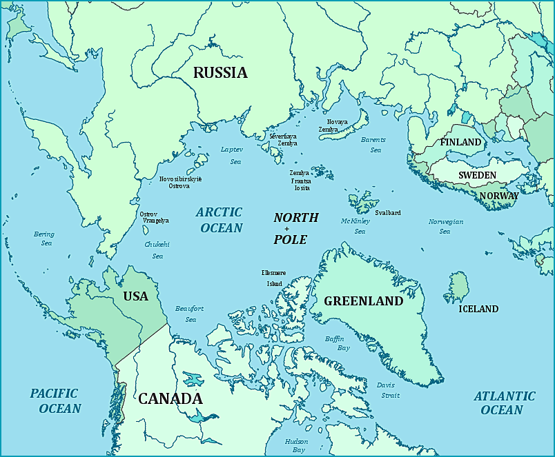
When was the last time you looked at the part of the world map way up north of Europe and Asia? I could probably draw a map of the countries surrounding the Mediterranean by heart, but I have no idea what’s going on along Russia’s northern coast. How many evil scientists are keeping their lairs up there?
The Diomede Islands in the Bering Strait
These two islands, Big Diomede and Little Diomede, are about 2 miles apart yet straddle the international date line, and so you can travel from one island to the other and thereby *go back in time*. Little Diomede is part of Alaska while Big Diomede is Russian, so technically speaking, the U.S. and Russia are only 2 miles apart from each other.
Svalbard (“More like Sval-brrrrd! Who’s with me? Am I right? Up top!” [hand slap])
Quick, let’s get this essay on the Svalbard Islands done, before Sacha Baron Cohen uses the name “Svalbard” for his next movie. Move, people! These islands are due north of Norway, waaay the hell up there in between Greenland and the very top of Russia. Svalbard is serving in part as humanity’s deep-chest freezer, as we’ve stashed the Global Seed Vault up there, buried in the snow. This vault keeps a couple seeds from plants found all over the world, stored in low oxygen and freezing temperatures, in case the poo hits the fan in more temperate regions. And before you ask, no, they aren’t storing any of *those* kind of seeds.
Severnaya Zemlya is another clump of islands up along the long-ignored Russian Arctic coast, to the right of Svalbard and off the coast of central Siberia. It wasn’t officially charted until 1933, making it the very last batch of islands to be discovered on the planet. Charmingly-named islands include “October Revolution” and “Bolshevik”.
Micronations
Sealand and other Micronations
If you think you’re a nerd because you like maps and geography, take a moment to feel better about yourself — you’re the Dos Equis guy compared to the mega-nerds who start their own micro-nations. These are extremely tiny “nations”, usually consisting of barely enough land to park a car, and almost always ignored by the country they’ve “seceeded” from. Many of these on land consist of either 1) a grumpy farmer seceeding when his country’s tax laws don’t go his way, or 2) clever eccentrics trying to drum up tourism business or 3) nerds who just have too much time on their hands. (Next time, why not instead start a nerdy website that no one reads?)
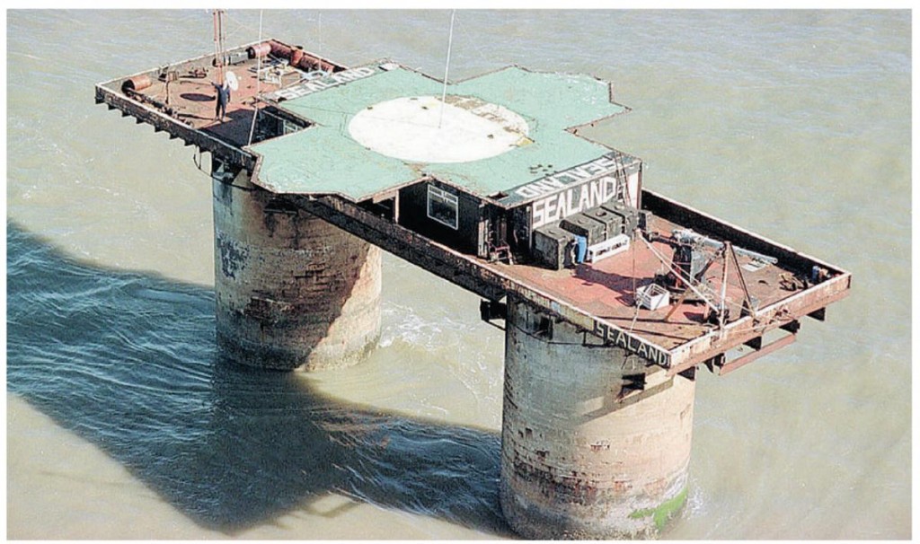
For me, though, the micronations founded out at sea are much more fascinating (and hilarious). I don’t know what I like better, their comically puny size, or their comically sad demises. You’ve probably heard of Sealand, a “nation” founded on an abandoned gun platform in the Atlantic Ocean, whose pirate-radio beginnings were featured in a recent movie, but is now being used for secure offshore web-hosting. Let’s meet a few of the other aquatic micronations that never quite made it:
| Aquatic Micronation | What is it? | Outcome |
| The Republic of Rose Island | 4000 square foot platform in the Adriatic | Siezed by the Italian Navy, who sent foursoldiers to assume command of the platform. Later demolished by explosives. |
| Leicester Hemingway’s country | 8′ by 30′ platform in the Caribbean | Pillaged by Mexican fishermen |
| Republic of Minerva | Artificial island created by dredging silt | Invaded and annexed by neighboring islandof Togo |
| REM Island | Large ocean platform used forpirate radio broadcasts | Seized by the Dutch military. They moved the platform to Amsterdam, where it’s now a restaurant. |
Can you imagine going through the effort of dredging up seafloor grime to make your own new island, only to have a neighboring banana republic wait patiently until you’re finished, then mug you for it?
Virtual Nations

King John of the Republic of Talossa. He would be quite right to point out how hypocritical we are in calling him "nerdy".
Finally, let’s poke some fun at purely virtual nations, countries that exist entirely as an online role-playing game. Try not to laugh — they might invade TimeBlimp. The Kingdom of Talossa was founded in 1979 by then-teenager Ben Madison in Milwaukee in his bedroom (HA!), and built a presence online in the mid-1990’s when dozens of people around the world became “citizens” (HAHAHA!). The members of the nation spend their time conducting role-playing games centered on diplomatic and political activities, like forming treaties, drafting laws, and the like (HAHAAHAHAAHAHAH!!!!). They’ve invented a back-story for their nation that traces their history back to North Africa (BWAAA-HAHAHAHAHAHA!!!!) and even have their own language (OH DEAR LORD!!!) and national anthem (PLEASE STOP! HAHAHAHAHAHAHAAA!!!!). They’ve also laid diplomatic claim to a large chunk of Antarctica (HA — ok, wait, that is actually pretty cool). Some schism apparently went down a few years ago, because there is now a rogue Kingdom of Talossa that has split from the canonical Kingdom of Talossa, plus a Republic of Talossa. Judging from what we know of misleadingly-named African countries formed after coups, the Republic is probably the brutal dictatorship, guilty of horrendous virtual civil rights virtual abuses and virtually rife with virtual corruption. Before we move on, I want you to picture in your mind’s eye, the type of person who 1) participates in online role-playing games, and 2) chose, as the subject matter for those games, NOT dragon-slaying NOR epic space adventures NOR hobbit-related nonsense, but *simulation of conducting diplomatic affairs and political treaties among sovereign nations*! I try to avoid casual swearing on this blog, but holy shit!
Countries that are an Offense to My OCD Side
There’s an OCD side of my personality that once organized my music collection by the color of the CD cover, resulting in a nice rainbow of jewel cases on the bookshelf (with the colors in proper Roy G. Biv order, of course). That part of me is deeply offended by these countries:
Namibia, a nation on Africa’s southwest coast, has this narrow finger of land appended to it jutting out 300 miles to the east, as if it were really happy to see Zimbabwe. Its sole raison d’etre was to get a land link to the Zambezi River. Unlike the rest of Africa, it’s now a peaceful, progressive region where many cultures get along. (I’m kidding! It’s seen more military action than Tommy Lee’s wang. Currently a civil war rages between the government and a liberation army bent on seceeding the strip from the union. Or the “Bobbiters”, as I like to call them.)
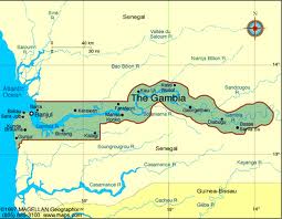 If Senegal, one of Africa’s more prosperous nations, were to get a colonoscopy, it would look like the nation of Gambia. This narrow country exists entirely within Senegal and consists of about 10 miles of land to either side of the Gambia River, as it flows from the African mountains down to the Atlantic ocean. This odd situation arose from colonial times (of course), as the British negotiated keeping land surrounding the river from the surrounding French territory. Legend has it the width was determined by how far a cannonball could be shot in both directions from the river.
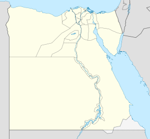 Have you ever wondered if there’s any land anywhere not owned by anyone? Some strip of grass along the highway that is simply unclaimed? Turns out there’s not a speck of land in the U.S. that isn’t owned by someone (or by the U.S. itself), but there are a couple spots of land around the world that are simply unclaimed — they belong to no nation at all. The only genuinely surprising example of Terra Nullis in the world today is the Bir Tawil Triangle, a tiny speck of land between Egypt and Sudan which neither country has claimed. Both countries claim an adjacent triangle-shaped wedge of land called the Hala’ib Triangle, but both spurn Bir Tawil, probably because it’s not shaped like a triangle.
Malta
There is the *island* of Malta (just south of Sicily), and then there’s the *Knights of Malta*, a sort-of-sovereign nation found in Rome. Who are these guys? Imagine if the Red Cross decided to secede from the Union, and that’s pretty much the idea. The Sovereign Military order of Malta is a medical aid organization, affiliated with the Roman Catholic Church, that is in some kind of quasi-independent status between independent nation and humanitarian group, somewhere in status between your local Rotary club and Taiwan. The Knights of Malta used to live on (and own) the Island of Malta, though they were kicked out by Napoleon, who conquered the islands in 1798. They currently have no actual territory, aside from two HQ buildings in Rome. They’re no small thing, numbering in the thousands, and do lots of good works around the world in providing medical aid and disaster relief. Malta the island, meanwhile, continues on to this day as their own nation (as they did for thousands of years before the Knights showed up in 1530) and is now one of them ex-British Commonwealth nations.
OK, this is ridiculous. I’m heading over to the Belgian town of Baarle-Hertog RIGHT NOW, with some Windex and a label maker. This town “borders” the Netherlands in the same way that mayonnaise borders egg salad. It looks like someone stuffed some Belgium in a shotgun and blasted it at the Netherlands. It’s apparently so fragmented that individual houses are split by the national border.
The Unorganized Borough: “Outlander!”
This is bar none the COOLEST sounding geographical area in the United States. In my imagination, this barren and forsaken wasteland is home to roving gangs of renegade energy pirates dressed like a Dio music video. At night, helicopters roam the land with their piercing searchlights, while daytime of course brings the stinging rain. In reality? It’s just the part of Alaska not in a borough (unlike other states with their counties, Alaska’s version of counties don’t actually cover the entire state). Still, the graphic of the Unorganized Borough is so cool that its going on my wall, next to the Che poster.
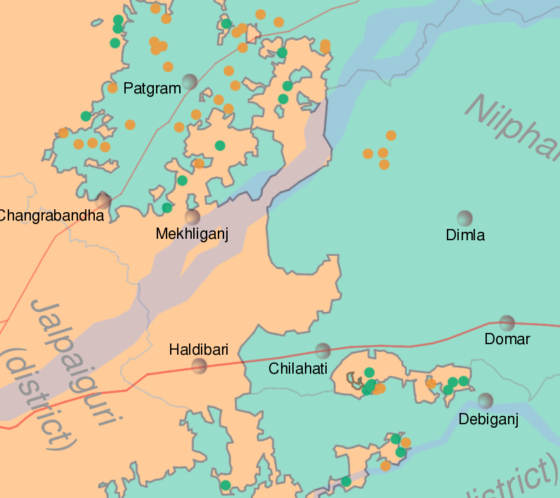 Probably the best example of extreme border issues is the state of the border between India and Bangladesh along West Bengal. In some spots, the border between these two countries looks like a fractal you had up in your dorm room before you replaced it with that Hendrix poster. The situation would be comical if it weren’t for the fact that it’s a humongous pain in the ass (and worse) for the people who live there. Here we find dozens of enclaves of each country in the other, and thanks to poor relations between the countries, life can be pretty miserable for those trapped in an enclave. What’s worse, we also find counter-enclaves — for example, a tiny bit of Bangladesh completely contained in a larger chunk of India, which is in turn completely contained in India. Rather than being a novelty and perhaps tourist attraction like in Baarle-Hertog, this convoluted situation leads to major problems for residents. The parent nation is usually refused easy access to its enclave, so it doesn’t even bother to provide services such as police or security forces, schools, power lines, running water, or even access roads. Imagine the siege of Berlin reflected in miniature, across hundreds of small enclaves along the border.
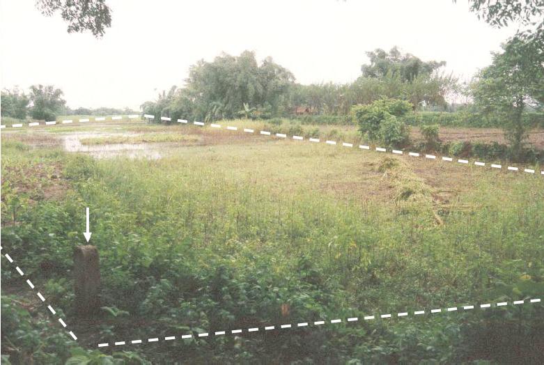 The situation reaches its peak at Dahala Khagrabari, the world’s only enclave-within-an-enclave-within-an-enclave. It’s a football-field sized area owned by India, contained completely within a Bangladeshi village, which is contained in a larger Indian village, which is completely contained in Bangladesh proper. Even smaller enclaves exist along the border, but this is the only 3rd-order enclave in the world. According to this cool blog article on it, this enclave is actually owned by a Bangladeshi farmer who lives next door who uses it for farming land. If we could convince him to swallow a clump of Indian soil, he could walk across his land and form a 5th-order enclave in his stomach. Let’s hope the news reports are true, that India and Bangladesh follow through with proposed plans to trade enclaves in hopes of simplifying the border situation.
(Thanks to whitesky60 on twitter for pointing this cool story out to me!)
Liechtenstein
Oh, and Liechtenstein is apparently the last vestige of the Holy Roman Empire. Just thought that was cool.

 Follow Timeblimp on Twitter